Letting folks sample history using socially distanced outdoor fun
by Larry Chowning
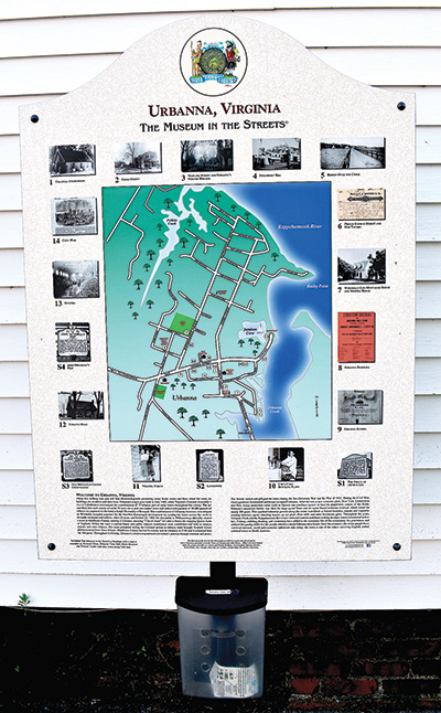
During this COVID-19 pandemic, a safe historical Rivah experience is taking the walking or driving tour of Urbanna’s Museum In The Streets, which provides an outdoor atmosphere with plenty of room for social distancing.
In 2014, former Urbanna resident Bob Calves was visiting a community in Maine where he learned of an international firm “The Museum In The Streets Inc.” (MITS) that worked with communities to setup historical tours.
Calves brought the Museum in the Streets concept back to Urbanna, encouraged the Urbanna Town Council to participate, and the council bought into the proposal. Calves also found grant funding to help the town offset costs.
The MITS tour is an historical and cultural alternative that is a bit different from traditional-style museums in the area.
“We design free walking tours that foster a sense of historical identity, educate, encourage preservation of local historic sites and promote knowledge of stores, events and traditions,” said Patrick Cardon, founder and director of Museum in the Streets Inc. and who worked with the Urbanna Town Council to come up with the town’s MITS program.
“Our historical panels, rich with local archival imagery, are installed in cities and towns around the United States and Europe,” he said. “The panels that make up the tour invite people to discover a town’s unique story at their own pace, over the course of an afternoon or several return visits.”
The Town of Urbanna was the first MITS Inc. project south of the Mason-Dixon line.
MITS Inc. is based in Cushing, Maine and the firm specializes in self-guided tours in historical towns and villages by using visual panels and brochures to direct the way. Urbanna’s tour consists of 18 panels throughout the town.
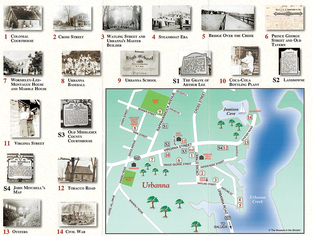 The tour is designed to highlight cultural and historical attributes of the town — from signers of the Declaration of Independence to a Tangier Island fisherman who feels his attendance at the town’s baseball game more important than the dollar he would make by fishing on into the day.
The panels, complete with historical photos, present many lively stories and facts about the town, its buildings, its residents and their lives. For instance, panel 8 is in the vicinity of where the town’s semi-pro baseball field was once located, today near where the town library is located on Grace Street. Alvin G. Loving purchased the land in the 1930s and for nearly 20 years the town had its own ballfield and beloved Urbanna semi-pro baseball team. “A Tangier Island man, Sol Shores, ran fishing parties on Saturdays, but, when the Urbanna team played he advertised to his paying customers that he would be back for the first pitch,” the panel states.
On panel 7 in front of the Wormeley- Lee-Montague house on Virginia Street, it states, “This colonial story-and-a-half (C1748) house is the oldest wood frame structure in town. In 1791, Revolutionary War diplomate and signer of The Treaty of Alliance with France, Dr. Arthur Lee acquired Lansdowne in town and also purchased this building. It is believed he used it for his office. When Lee died he left his estate and this house to his brother, Richard Henry Lee, who was author of the Resolution for Independence and a signer of the Declaration of Independence.”
On panel 9 at Urbanna’s Tabor Park on Rappahannock Avenue, the panel highlights Urbanna Elementary and High School that operated on the site from 1909 to 1962 and panel 14 at the town-owned marina at the very end of Virginia Streets highlights events along the waterfront during the Civil War.
As part of the program, MITS Inc.’s website promotes participating communities and provides additional app programs to allow for even more history, above what is on the panels, to be told at the sites. The virtual MITS signage and brochures for the tour was completed in 2017. A map panel of all the sites on the tour and a brochure stand is located on Cross Street beside Bristow’s Store.
The Town of Urbanna has a “historical district,” which is listed on the Virginia Landmarks and National Register of Historical Places. The Urbanna Historic District was created in 1991 and panels are erected throughout the district.
The Urbanna Town Council hired Ray Rose in 2019 to put together a virtual museum tour with more photos where all 18 sites can be scanned with a free HP Reveal app. The virtual site was designed to assist visitors with sight disabilities and to provide more historical photos and images for those wanting to take the virtual tour experience.
The virtual walking/driving tour is free and only available by scanning the MITS history markers in person in the Town of Urbanna. Each of the 18 marker videos average from two to three minutes. Contact Town Administrator Holly Galley at 804-758-2613 or Ray Rose at 804-577-7100 for information on the app for cell phone use and/or leave a message in order to schedule a time to use a device with the app already installed.
Urbanna Town Museum has 1700s Mitchell map
by Larry Chowning
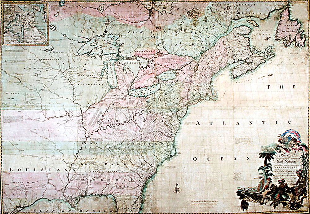
The Urbanna Town Museum and Visitors Center, located on Virginia Street, houses a 1755 first edition John Mitchell Map, known as the “Map of the British and French Dominion,” and considered the most important map in American history.
Dr. John Mitchell practiced medicine in Urbanna from 1734 to 1745 from his home and office on Virginia Street located near where the post office and ABC store are located today.
On occasions at the museum, Urbanna resident Dr. Paul Malone dresses the part and tells the story of the map and John Mitchell.
“The Mitchell Map is the single most important map in American history and a guy from here in Urbanna, John Mitchell, is who sat down and put it together,” said Malone.
History of map
The year 1980 marked the 300th anniversary of the Town of Urbanna. Three-hundred years prior, the Virginia General Assembly in 1680 had approved an Act of Cohabitation, designed in-part to create towns in Virginia.
That year, England’s king, Charles II, encouraged Virginia’s governor, Thomas Culpeper, Baron of Thoresby, to urge the Colonial State Assembly in Jamestown to encourage Virginia colonists to establish towns.
There were 20 town sites created on paper throughout the colony and one was in Middlesex County “on the west side of Ralph Wormeley’s creek against the plantation (Rosegill) where he now lives.”
As part of the 300th anniversary, the Urbanna Town Council officially appointed in 1979 a 300th anniversary Tricentennial Committee, charged with planning and overseeing a year long celebration. Jessie DeBusk and the late Stuart Chewning were co-chairman of the committee. DeBusk at 102 years old is today the oldest living resident in Urbanna.
From the work of that committee came the first Urbanna history book, “Urbanna A Port Town in Virginia 1680-1980,” compiled and published; a historical community play performed behind the old Tobacco Warehouse; a replica of a colonial Rosegill wine bottle was reproduced and sold; and the community purchased a 1755 copy of the John Mitchell Map.
DeBusk worked for the Bank of Middlesex and in 1975 bank president Gene Paulette encouraged Jessie to research history of the bank as part of the bank’s 75th anniversary. Through that research, she learned about John Mitchell.
In 1976, she was a member of the John Mitchell Garden Club and attended a historical talk about Mitchell. The speaker, Catesby Jones of Gloucester County, questioned why the Urbanna community, where Mitchell lived for nine years and practiced medicine, was not more involved in spreading the word of Mitchell’s historical significance.
“I asked several people in the club and in town about John Mitchell and they knew very little about him,” said DeBusk.
Through research, DeBusk determined Mitchell practiced medicine in Urbanna from 1734 to 1745 and lived on “Physick Lane” on lots in town that now include the post office, old Carl and Pearl Tomlinson home (torn down) and ABC store, “right in the center of town,” she said.
While living in Urbanna, Mitchell, also a botanist, discovered partridgeberry in local forest and the plant is named in his honor “Mitchella repens”. The present day Middlesex County seal includes an image of partridgeberry along with other county images and his discovery was the reason Mitchell was the namesake of “John Mitchell Garden Club.”
DeBusk also learned that Mitchell had international fame as a mapmaker. The Mitchell map was used as the cartographic document consulted by Great Britain and United States officials at Paris, France in 1782 and 1783 negotiating the treaty that terminated the Revolutionary War and recognized the independence of the United States. It determined the official boundaries of the 13 original American Colonies.
Some years later, in 1790, Thomas Jefferson, then Secretary of State, questioned who had drawn the Mitchell map. None other than Benjamin Franklin, a longtime friend of Mitchell, made it clear to Jefferson and others that “I now can assure you that I am perfectly clear in the remembrance that the map we used in tracing the boundaries was brought to the treaty by the commissioner’s from England and that it was the same that was published by Mitchell 20 years before.”
Mitchell published the map at the request of the British Board of Trade in London in 1755, and it was reprinted on the original scale at least 17 times before 1792 in England, France, Holland and Italy.
“During the early stages of planning the Urbanna tricentennial we started discussing what should be done to celebrate our 300 years,” said DeBusk. “I mentioned to Mr. Paulette that we might consider purchasing a Mitchell map, if we can find one.
“He encouraged it and the search began,” said DeBusk. “After two years of searching, Mrs. Parks Rouse in Williamsburg found W. Graham Arader III, a dealer in rare books and maps, who had a Mitchell map who wanted to sell it for $7,500. He indicated it was a first edition, third impression of the map.
On May 31, 1979, DeBusk, Carl Terrence and Charlie Price set out “on a foggy morning” to meet Robert (Bob) Montague III and members of the Library of Congress in Washington, D.C. “to learn what to look for in (authentic) old maps.”
After the meeting, they drove to King of Prussia, Pa. to Arader’s home, saw the map and had it examined by experts. The map was purchased for $7,500 and delivered on June 1, 1979 to Urbanna. The bank and town council donated a portion of the funds and the tricentennial committee conducted a fund drive, which raised a large portion of the funds needed to purchase the map, said DeBusk.
It was recently appraised by Turner C. Johnson Jr. of Richmond at a value of $575,000. The map hangs on the wall in the town museum and can be viewed by the public when the museum is open. The Urbanna Museum and Visitors Center is currently closed due to the COVID-19 pandemic.
